8/16/09

Stage 14: Crested Butte, CO - Fruita, CO

Sadly, our time in the mountain paradise of Crested Butte had to end. I could have stayed all summer but, lest we forget, we set out on this journey with bigger goals than spending the month of August riding mountain bikes and sipping pints of delicious brew. We had to be in Portland by the 17th, and still had a lot of country to cover before we could move into our new apartment and sleep in our own bed once again. We rolled out of town and headed northwest toward Fruita, a sleepy farming town near the Colorado border with Utah. Most people would have never heard of this quiet little town, but the fat-tire faithful know Fruita for her miles upon miles of widely heralded desert singletrack. The drive wasn’t too long, and put us into town around 2:00, with plenty of afternoon left for riding. We had heard tell (from our helpful friend who helped us solve our roof rack issues at REI, among other people) of a trail called Zippety-do-dah in the foothills of the Book Cliffs outside Fruita. It sounded like great fun, a roller-coaster ride of smooth desert trail, so we thought we’d seek it out. We found our way to SingleTracks bike shop in downtown Fruita, and weren’t even sure if there was anyone working in the store. We wandered around, found the trail maps, which also had clear directions to the trailhead, and only then saw someone who appeared to be an employee fiddling with the front wheel of some kid’s Wal-Mart BMX bike. He didn’t look up as we walked through, so we made our circular tour of the shop, eyeing the fancy bikes hanging from the walls and ceiling, and back out the front door. I think everyone feels condescension from snobbish bike shop employees from time to time, but at least those rude people recognize your presence for long enough to make a jab at your apparent ignorance. I’ve never been totally ignored in a bike shop. Not one this small, anyway. Whatever, I didn’t really have the money to buy anything, the trail map was free and now I didn’t feel obligated to buy anything.

So, off down the 18 Road and to the trailhead we went. We found the place without any trouble, out in the desert past the edge of town where the roads turned to dirt. There was plenty of camping right at the trailhead, so we parked the car, pulled the bikes off the roof, laid our plans for the ride, ate a quick bite and made ready to hit the trail.

Stage 13: Strand Hill Trails

We woke for another delicious breakfast at the Elk Mountain Lodge and fueled up for another day of riding. Still achy from the 401, we decided to do a shorter loop that wouldn’t require as much climbing, and decided to ride the Strand Hill trails, just west of downtown. There were several shorter trails that we could connect to make a ride however long we wanted. Also, the Strand Hill Trail itself was reputed to have one of the best descents in Crested Butte. We headed out of town...

and picked up the singletrack paralleling hwy 135, then picked up Brush Creek road. The road soon turned to dirt, but didn’t climb to the sky as steeply as Gothic had yesterday. We followed this road all the way up the side of Strand Hill until it turned into a jeep trail,

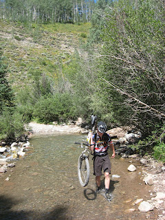
then split off on a steep, downhill piece of singletrack to a creek crossing. We shouldered our bikes and forded the shin-deep, freezing cold water to reach the trail on the other side.

We descended the Strand Hill Bonus trail for about 3 miles, through a tricky little rock section,

And down to the bottom of the Strand Hill trail itself. The hilltop at the crest of this trail was supposed to have a nice view of the surrounding mountains, and we would have climbed straight up it. Fortunately, we ran into a fellow rider at the bottom who advised us to continue on the Bonus trail and take a left on a forest doubletrack rather than ride up Strand. We heeded his advice, and even though the doubletrack turned out to be a mile-long slog over baseball-sized rolling rocks that my beat-to-death legs just couldn’t handle, the descent of Strand Hill was one of the best downhills I have ever ridden and was worth every second of suffering on the climb. Strand was fast, smooth, with naturally bermed corners formed of perfect hardpack, punctuated with occasional rooty sections or rock drops to keep you on your toes. The trail tightened up near the bottom, threw in a couple of quick switchbacks in between pump bumps and point-and-shoot rock sections where all you could do was point it straight, feather the brakes and hope for the best. Great fun. From the bottom of Strand Hill, we cruised ever downward on the Canal trail, a smooth, easy section that humped up and down over the hillside rollers on the way back down to the dirt road, and home. This ride was a good 2 hours shorter than our 5-hour day on 401, but didn’t allow for much of a recovery.

Back in Crested Butte, we were ready for another late lunch/early dinner and walked to Teocalli Tamale for Mexican food and Margaritas. After a pitcher of margs, an enchilada plate for India and some delicious fish tacos for me, we cruised the strip in search of postcards, and found some good ones at the Crested Butte Mountain Museum and Mountain Bike Hall of Fame. We decided to save the $3 entry fee into the museum for another trip, but came away with some good postcards. We walked down to the dirt jumps to see if anyone was riding. I really wanted to see someone airing out the big doubles on their BMX or mountain bike. The jumps were empty, but we had a good chunk of daylight left so we trekked back across town to the hotel and grabbed our bikes and lowered our saddles for a little session on the pump track. It didn’t take too long before our legs and lungs were howling for mercy, and by then the sun was starting to set. I aired out the jumps one last time for the crew of local kids that showed up, then we rolled back to the hotel for some well-deserved rest before our drive the next morning.

8/15/09

Stage 12: Trail 401

We woke bright and early to be sure we didn’t miss breakfast provided by our gracious hosts at the Elk Mountain Lodge. We filled our bellies with quiche, bagels, granola, yogurt, and plenty of fruit and coffee, then returned to the room to pack our gear and get ready to hit the trail. We packed tubes, tools, pump, 4 energy bars, 4 packs of shot bloks, 2 energy gels, and about 170 ounces of water between my Camelbak and 3 water bottles. This was going to be a long ride. Before we even got anywhere close to singletrack we had to endure a 15 mile climb out of town on Gothic Road, up through Mt. Crested Butte, out to where to road turns from pavement to dirt, steeper and narrower at it climbs up, through the tiny town of Gothic, and ever upward, clinging to the hillsides in tight, potholed switchbacks covered in moondust and loose rock. Almost too steep to climb seated, nearly too loose to climb standing. If it weren’t for the absolutely stunning scenery all around...

and the mythical singletrack to come, it would have seemed like pointless suffering. It was only a sense of pride that kept me from pushing my bike up some of the steeper sections. This brutal leg-smasher of a climb would take us from downtown Crested Butte at about 8,800 feet all the way up to Schofield Pass at about 10,100 feet.

We paused at the top for snacks and water, and chatted with a group of sightseers who had driven their truck to the top. While we rested, another group of riders rolled to the top of the pass, a crew of about eight from someplace in the Midwest, many of who were gearing up for the Leadville 100 on Saturday.

If you’re not familiar with Leadville, it’s a small town in Colorado that hosts an annual 100 mile mountain bike race with a something like 12,000 feet of climbing. It’s a brutal endurance event dominated by Dave Weins, a former pro mountain bike racer who is “retired” from racing, but has won Leadville for the last 6 years running. Floyd Landis tried to beat him and failed. Lance Armstrong tried to beat him and failed. Weins sets the bar ridiculously high, but the race is open to anybody crazy enough to register and fast enough to finish under the time cutoff.

Basically, these guys from the Midwest who just hit the top of Schofield pass with us were some grade-A mountain bike maniacs. We let them go ahead to start up the first section of trail, figuring that they would be much faster than us up the final climb to the very top of the 401. We started up not long after, and found that we had some sadistically steep singletrack to climb before the real reward for our efforts. I didn’t have much juice left in the legs to climb with anyway, but any chance I would have had to clear some of the steeper sections was foiled by the stragglers off the back of the Midwestern group. It’s pretty much impossible to stay on the bike when you’ve only got one gear and you’re stuck behind someone spinning up the steep stuff in the granny. I’m not saying I would have been able to ride all the way to the top, but it would have been nice to have a shot at it. Oh well, maybe on another trip… After a little over a mile of climbing, we finally topped out at the high point of the 401. Our Midwestern friends were stopping here to eat lunch, and we were still pretty well fueled from our stop at the top of the pass, so we downed a little water, posed for a picture,

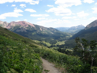
and started down the swooping lines of dirt laid out across the hillsides. What a ride! There were a couple of tricky technical sections, some tight switchbacks and steep drop-offs to the side, but most of the next 5 miles was fast, smooth, rip-roaring trail through the wildflower-covered mountainsides.

I had to stop every now and then just to take in the view, since trying to admire the mountains all around while trying to keep my tires on this foot-wide sliver of dirt proved to be impossible.

We finally hit the low point of the 401 at a small creek where we paused for a breather. We splashed the dust off our faces with the icy cold water; a welcome relief from the unfiltered mountain sun and thin, dry air and headed back down the trail.

We wound around creek level for a while, then began a series of short ups-and-downs to get us around the corner of the mountain and back to the road. We were both already nearing the point of exhaustion, and had little left in the tank for climbing. Pride and determination were simply not enough to keep me on the bike for some of these climbs. It was then that I realized that my bike has two speeds: riding speed and walking speed. Walking speed turns out to be about the same as granny-gear speed, but without the pride and sense of accomplishment of being able to ride up the steepest sections of trail. As much as I love my Ol’ Burly Surly, a bike with about 5 inches of suspension travel and a whole bunch of gears might be in my future… We survived the final sections of trail and found our way back to Gothic Road and our final descent back into town. Just before we hit the ski town of Mount Crested Butte, we caught back up with our Midwestern friends who had passed us on the final uphill sections of trail. Most of them were going down the Snodgrass trail to add another few miles of singletrack. With almost 30 miles of riding already behind us, we thought that pizza and beer sounded like a better plan, so off down the road we went. On the way back into town on the bike path, I noticed some smaller bumps off to the side of the city dirt-jump park and decided to investigate. We found a nicely packed pump track of tight berms and 12-18 inch high rollers, almost like a concrete skatepark for mountain bikes. I pumped the humps for a few minutes, but didn’t have much energy left for playing. Maybe tomorrow…

We got back to the room thoroughly whipped, showered our tired bodies off, and made for the umbrella-shaded patio of the Brick Oven pizzeria. With pints and slices in our bellies, we were feeling pretty good. We wandered around downtown for a while, watched the people go by on their cruisers and marveled at the wonder and greatness of this place, this tiny mountain town that might just be the best place in the world if you love to ride trails. Before long, we shuffled back to the room to rest our tired bodies for a while before turning in for the night.

8/14/09

Stage 11: Upper Loop - Upper Upper Loop – Whetstone Vista

Our route took us up out of town on the city bike path, a paved greenway type trail that took us about 3 miles up to the ski resort village of Mount Crested Butte and onto the lower slopes of the mountain itself. Even this relatively short, mild climb had our lungs working overtime to milk every bit of oxygen from the thin mountain air. Once we reached the ski town, we turned off the bike path onto a residential street that soon turned to dirt as it traversed the mountainside, then dead ended with a sliver of dusty trail the only way forward.

“This is our trail,” I said.

“Okay, let me get some water,” India said. We drank some water, ate some Shot Bloks and got ready to drop in for the first little descent. I rolled in first, down a short downhill with some loose rocks, into a an aspen grove, and heard a thud and a yell. I stopped, heard some moans from behind me, and quickly turned my bike around to find India tangled up in her bike off the downhill side of the trail. I helped her up and got her free from the bike, and asked her what happened. It was the classic mountain bike crash where you look directly at the obstacle (in this case, a rock in the middle of the trail) you want to avoid, and rather than neatly skirting around it, you plow directly into it. The rock bounce, combined with heavy front wheel braking and a soft outer edge of the sidecut trail, wound up pitching her over the side. A little shaken up, but undaunted, she duster herself off, took stock of her scrapes and bruises, and continued down the trail.

Sadly, we forgot to bring the camera along on this ride so we don’t have any pictures of our first ride in the real mountains, and I know that I don’t have the talent to do justice to the beauty of this place with words, so just use your imagination. The mountains all around look just like the towering slopes of the Alps that we see every July in the Tour de France, and the dusty dirt roads generate instant flashbacks to the tour of the 20’s and 30’s when dirt roads were more the rule than exception. However, even those hard-nosed tough-as-nails bike racers would have been horrified by the idea of riding their skinny-tired road bikes down this rocky and technical trail across the contours of Mount Crested Butte, through aspen groves, alpine meadows, and up and down steep slopes. It was a humbling ride for both of us. While surrouned by so much absolutely beautiful scenery that it is nearly impossible to keep your eyes on the trail ahead, these trails were also incredibly challenging. There wasn’t a great deal of sustained climbing on the Upper and Upper Upper trails, but even the short little grunts up rock and root strewn steeps were leaving me breathless. We took a little bit of a shortcut down the Whetstone Vista trail, a quick set of switchbacks that dropped us just southeast of town. After a quick jaunt on the road and down a little singletrack paralleling the highway back to Crested Butte, we were back in town, hungry and ready for a cold beer.

We stopped at ACME Liquor on the way into town and picked up some cans of Dale’s delicious Rocky Mountain Pale Ale (probably the best canned beer ever) and eagerly cracked it open when we got back to our room. We had a beer, showered off, and made for the hotel kitchen to make some spaghetti for dinner. We ate hungrily and discussed riding plans for the next two days. All we really knew was that Trailriders Trail #401 was a mandatory stage in our tour of Crested Butte. This is the slice of singletrack that put Crested Butte's star on the map of the Mountain Bike world, and is perennially listed as one of the best trails in North America. This is the trail that all other trails in the Rockies are measured against, the trail that lowlanders like ourselves can only dream about as we ride the Blue Ridge and Appalachians. As if all the hype and legend surrounding this trail wasn’t enough, all Greg (aka Giggles, former co-worker at Sunshine and everyone’s favorite Belgian bike mechanic) had to say when he found out we were going to Crested Butte was, “you’ve gotta ride the 401.” After some deliberation, we concluded that tomorrow was the day to take a stab at it, before we got too many more hard miles of Rocky Mountain climbing in our legs. We fell asleep quickly in the comfortable bed at the Elk Mountain Lodge, hoping for a good night’s sleep to fuel the big day ahead.

Stage 10: Taos, NM - Crested Butte, CO

We woke early and found nose prints and lick marks from a herd of curious cows all over the car. I guess dusty old Simon must have tasted good. We made tea, broke camp, repacked the car and prepared for the drive down the mountain road back to town. Then, we thought, why waste a perfectly good dirt road downhill in a car when we’ve got bikes right here with us? Not only would it be more fun than driving, but having one less body and bike weighing the car down would give us a little more ground clearance. After a little convincing, India was mounted up, and off down the mountain we went.

When we got to what felt like the halfway point to her, India pulled over to let me have a turn. I grabbed my helmet and jumped on her bike, and rode maybe a quarter mile before hitting the bottom at the intersection with the highway. Oh well… Not much of a ride for me, but it was fun driving the car behind. If only we had radios, a crate full of water bottles to hand out and a mechanic to lean out the window and make rolling adjustments.

We hit the highway and headed for Crested Butte, high in the middle of the Rocky Mountains. We crossed over the Rio Grande gorge,

and into Colorado.

We steadily climbed through the foothills, through canyons,

along mountain streams and arrived in Crested Butte right about 3:00. We checked into our room, dropped off our stuff, and headed for Big Al’s bike shop for a trail guidebook, bottle cage, and a pair of gloves. Then it was time to gear up and get out on the trail! We had both been itching to ride for quite some time, feeling a little pudgy after lots of driving and eating, so we dug into the guidebook, found ourselves a short loop from town that looked like a good introduction to Crested Butte singletrack, checked our tire pressure, and rolled out.

8/11/09

Stage 9: Kingston, NM - Taos, NM

As there was no threat of rain when we hit the sack at our little campsite in the Gila national forest, we pitched our tent without its rainfly to allow a little more ventilation. Without the extra shade of the fly, we woke soon after first light and started shuffling about. I fired up the camp stove to warm up some coffee in my thermos from the day before, and we each had a warm mug to sip from while we broke camp and prepared to head north. Since we drove in and made camp in the dark, we hadn’t been able to appreciate the beauty of the area we drove through to arrive there. Still in the Rio Grande valley, the area was mostly dry with some wild, rocky landforms, but our little campsite was on the banks of a feeder stream and was fairly well forested.

The drive across the vertical axis of New Mexico was a great deal less interesting than the drive across Texas, but was about half as long, and we made it all the way to Alameda before the voracious cravings for breakfast food kicked in. We found a little place, right on the main downtown street called the Fresh Tortilla Company that made its own delicious tortillas, salsas and such. We each got huge servings of delicious breakfast food and took them to go. We wandered the town for a while looking for a nice place to eat outside and found the campus of a small community college with some shady trees and freshly mowed grass. We gorged ourselves on the huge portions of eggs, beans, potatoes, sausage, cheese and salsa, and headed back out on the road.

The drive to Taos was fairly uneventful, but we made good time and pulled into town with plenty of day left to explore. We made our first stop at the grocery store to pick up some food for the night’s camping and lunchtime snacking, then on to the visitor’s center to try to find some information on local trails and campsites. We had already chosen a site in the Carson national forest that looked easily accessible from the highway, but since we came into town with some extra time, we thought we might explore a little, maybe get a ride in, and camp. Unfortunately, the episode to follow became one of the only misadventures of our trip so far.

The map we secured from the visitor’s center showed what appeared to be a fairly thorough overview of the trails in the Carson national forest, so we headed out hwy 64 in search of a particular forest service road that might take us to a worthwhile trail. It wasn’t until we were well into the climb up this bumpy, rocky, forest service road that we realized that all of the “trails” and “rides” listed on our visitor’s center guide were not singletrack, but dirt roads, and that there was no scale at all to the map. How far had we to go on this steep, sometimes rutted climb in our heavily loaded little car before we reached something resembling a mountain bike trail? Long before the road topped out, our frustration started to bubble up. We stopped, ate some turkey & cheese tacos, and reassessed the situation. There was no sense in turning back now, as we had to be getting close to the summit of the mountain we had been steadily climbing. We ate some food to calm our ornery hungriness, took stock of the situation, and decided to press our luck and continue up the mountain road. We eventually reached the summit and Garcia Park, an open area of campsites, grassy meadows, aspen groves and home to a herd of grazing cattle. After some debate and discussion over who wanted to do what, we decided to spend the night in this beautiful place rather than driving back down the mountain to our previously planned campsite.

The beauty of the place started to melt our stress away, and we decided to make a short two-wheeled reconnaissance mission of our surroundings. We rode some forest roads, some doubletrack,

found an Aspen with my sister’s name carved into it,

and took a chance on a section of singletrack trail that was not shown on our map and not marked at its junction with the forest service road. Maybe on another trip this one would be worth exploring more fully, but when the trail is littered with loose rock and tight switchbacks and you have to climb back up anything you descend and darkness is closing in on a mountaintop in New Mexico and the tent hasn’t yet been pitched and BEAR! A baby bear, not any bigger than a small, stocky dog ran across the trail less than 20 feet in front of me. I looked to the left where the little bear had run and saw what looked like a fully grown mama bear, lumbering off through the woods. India was far enough behind me to be out of earshot, so I sat still, listened and watched for any more noise or activity. By the time India rolled up next to me, I was fairly confident that we were safe and weren’t about to be sideswiped or attacked by a mother bear. We rolled on down the trail, down another corner that took us deeper into the area of woods that the bears had run too, and I decided it was time to turn back. We took a few detours on the way back, and returned to camp feeling much better about life in general, but a little worried about the bears. Hopefully the activity of the cows on our little mountaintop would help keep us safe. We pitched the tent,

started our campfire,

and shared a cup of tea before turning in under the beautiful stars with the jangling cowbells to lull us to sleep. I woke a couple of time during the night with tremulous dreams, and once when the herd of cattle was moving right through our campsite, even trying to chew on the corners of our tent! I kicked at the corner and yelled git! And the confused cow seemed to wander on. India nearly slept through it all and I eventually joined her in a deep sleep.

Stage 8: San Antonio, TX - Kingston, NM

Okay, here we go. This drive will be the biggest and longest of our trip: nearly 700 miles all the way across Texas, along the Mexican border, through El Paso and into Southern New Mexico. As few stops as possible, no family to see, no friends to visit, just an entire state to cross and one day to do it in. We were treated to a good breakfast by our hosts at the O’Casey B&B, and hit the road a little before 10 am. Back to US-10, and across the entire width of Texas. I was expecting an incredibly boring drive with lots of flat, barren desert land with nothing really to look at, but I was pleasantly surprised by all the variety and beauty of central and western Texas. There was some arid and flat desert land, but the majority of the drive was filled with big skies,

rolling country,

dynamite cuts through the hillsides,

oil derricks,

and dust devils!

Oh, and I don't know if you knew about this, but in Texas they have one rule that goes above and beyond all others. It is the long history of this one golden rule that allows the state flag of Texas to fly as high as the stars and stripes, the capital dome in Austin to be as tall as its national counterpart in Washington DC, and the sovereign state of Texas to secede from the Union at any time it sees fit.

You just Don't Mess With Texas, plain and simple. Look what happened to Saddam Hussein. He only messed with Texas indirectly, and now he got executed! Seriously. DO NOT mess with Texas.

Once we hit the town of Esperanza, our route paralleled the Rio Grande and put us within sight of Mexico. Oddly, I didn’t see much of the crazy “border war” that we’ve heard so much about in the news. The Rio Grande valley looked pretty peaceful from our well-removed, comfortable seat in a car barreling down the highway, but we did get a couple of looks at the south-of-the-border town of Ciudad Jaurez, just across from El Paso.

After our brief borderland experience, we turned north into New Mexico.

It was here, cruising north on I-25, that we had our encounter with the United States Border Patrol. Our two lanes of fast and smooth highway were narrowed to one by a line of cones, and a sequence of signs on the shoulder told us that all cars must exit to the inspection station. We don’t have any photos of this episode in the journey because I was afraid the border patrol officers might accuse us of conspiracy to commit acts of terrorism or something of the kind, so I quickly stashed the camera and began hunting for all the important documents that cops usually ask for at roadblocks: driver’s license, proof of insurance, vehicle registration; and even some that only the border patrol might care about: passport, birth certificate, marriage license, etc. We rolled up to the stop, hoping that the officer wouldn’t see any reason to search our car filled to the brim with everything we’d need for a 2-week trip across the country and the start of our life in Portland. India rolled down the driver’s side window as we pulled up to the inspection point and greeted the young man in a border patrol uniform who walked up to our car. He only had one question: “American citizens?”

“umm, yeah,” India replied.

“Move along.”

“Oh… thanks…”

And we were on our way. That was it. The whole time we were in the borderlands I kept looking for signs of this wall being built between the US and Mexico, but didn’t see a thing. I imagine we just weren’t close enough.

Once we were in New Mexico, we were ready for a good night’s sleep but were still a little hungry, even after a late lunch. We tried to stop for dinner in a little farm town near where we would camp the night, but the only restaurant in town was closed when we arrived at about 7:30. We headed up the road peeved and tired, but still on the lookout for dinner spots. No food options showed themselves, but we did enjoy a beautiful sunset over the plains of New Mexico as we drove the winding roads toward our campsite, just outside of the tiny town of Kingston in the Gila National Forest.

We found our little hole in the woods, pitched our tent in the dark, had a light dinner of Clif bars and Lone Stars while we watched the stars come out, and turned in for the night.

Stage 7: Wildwood, TX – Katy, TX – San Antonio, TX

We woke early for a steak and egg breakfast with the grandparents, hoping to get an early start on our trek to San Antonio. The night before, we called India’s aunt, Julie who lives outside of Houston in the suburb of Katy, TX and made plans to meet for lunch at her house. We threw back our coffee, downed our steak and eggs, packed the car, paused for a quick photo (I apologize for the blue-tinted photos that will follow. Our camera is nothing if not sketchy. I guess that's what falling off a car roof onto asphalt at 25mph will do.) with our wonderful hosts, and hit the road.

The drive through Beaumont and Houston to Katy was uneventful, but not too trying. Traffic outside of Houston was fairly calm, as we managed to miss the crush of rush hour.

Houston appears to be one of the few cities that rivals or even exceeds Atlanta’s uncontrolled sprawl. Any city with two perimeter highways is doing something wrong in my book. Anyway, we made it into Katy and caught up with India’s aunt Julie and cousin Tate for a quick wedding picture slideshow and lunch. We talked about the wedding, the honeymoon, and the 8 months that Julie’s parents (India’s grandparents) waited out hurricane Ike in the small house in Katy while they were evacuated from their former home on the Bolivar peninsula, and while they searched for a new place after it became clear that the hurricane had destroyed their old home. I can’t imagine the feeling of having the home that you designed, built and lived in for more than 25 years literally wiped off the map and turned into a mud field. I was also blown away by the amount of damage the hurricane did as far inland as Houston. Julie and Tate’s neighborhood was without power for more than a week after and they lost some major chunks of roof, but everyone came out of the ordeal pretty much unscathed and unhurt. We were certainly counting our blessings that we don’t live anywhere near hurricane country.

After lunch we climbed back into the car and headed back to I-10 towards San Antonio. We rolled into town in the late afternoon, but the sun was still hot and bright, beating down on the broilerpan of the city with white intensity. We arrived at the O’Casey bed and breakfast...

and were greeted by a serious gnome theme in our room. There were gnomes describing all the important features of the room, including the lightswitch,

Bed,

Kitchen,

And toilet.

Without these little hatted helpers to guide me, I would have been completely lost and would have probably tried to sleep in the toilet, flip the bedswitch and urinate on the porch light. Thankfully, we had no such trouble. After a quick change of clothes and check of the clock, we decided that we had better make for downtown and the Alamo before it closed at 5:30, so we hopped on the bikes and made the short trek into downtown San Antonio.

The Alamo itself was pretty inspiring and gave me a little insight into the intense pride that Texans take in their state. It’s hard to imagine what would inspire men from all across the country to come and fight and give their lives for Texan independence from Mexico when they seemed to have no real stake in the fight, but maybe I just don’t know the whole story. But, it was pretty wild to see some of Davy Crockett’s personal effects, his rifle, a beaded vest, letters that he wrote and some other things that showed that he was indeed a real person and not just a legend from Saturday morning cartoons. He was also a Freemason, along with several other prominent Alamo fighters like James Bowie and William Travis.

Who knew? Another layer to the mystery… The conspiracy theories surrounding Freemasonry and the birth of the United States could fill volumes… Oh, and here's India by her favorite tree in Texas, the huge live oak at the Alamo that is so huge that several of its branches have to be held up by steel cables!

After our visit to the Shrine of Texas Liberty, we made for the San Antonio Riverwalk, the super-touristy Disneyland “downtown” surrounded by cheesy themed restaurants, gift shops, and motorized cattleboat gondolas that circle the concrete river loaded down with huge families of tourists. We lingered for a while to watch some ducks diving in the water for their dinner, but quickly tired of the theme-park vibe and thought we’d find somewhere to eat that was a little bit off this beat. We were feeling half-starved and ready for some Mexican food and margaritas, so he headed up to street level from the riverwalk and made our way into the first Mexican restaurant that looked appealing. We found ourselves a seat outside on their balcony that happened to overlook… the Riverwalk! Despite our disappointment at being unable to get away from the outrageous touristy-ness of the city, at least we were up out of the melee on a balcony where we could sit and people-watch while we drank our margs and ate tasty food. The food was good, but not amazing and the margaritas may have been a bit overpriced, but we left with full bellies and no complaints. We found our bikes again and rode home, stopped by a drive-through beer store for a 6-pack of Lone Star tall-boys, and headed for the B&B to make our plan of attack for the next couple of days. All the main protagonists (Plant, Brownie, Fly, and Ol' Surly Burly) nestled neatly into our little room, and we sat down at the desk to polish out the details.

Tomorrow would be our big grind across the remaining central and western portion of the great state of Texas, taking us all the way to the bordertown of El Paso, just a stone’s throw from Mexico. We wrote down precise directions to our camping destination in the Gila national forest, then on the next day through New Mexico to the Carson national forest. Plans made, we turned in under the watchful eye of the gnomes for a good night’s sleep before the next day’s Texas blitz.